Through this chapter, we will know the detailed and important information of Daman And Diu, in which important and interesting information like history, geography, economy, education, culture and world famous tourist places located in the state have been added. Apart from this, the recent developments and changes in the state of Daman And Diu have also been explained in detail. This chapter is full of interesting facts for the competitive aspirants as well as the readers.

Quick General Knowledge

State LevelUnion territories
CapitalDaman
Statehood30 May 1987
Total Area112 sq km
Districts112
Current Chief MinisterPraful Patel (Administrator)
Current GovernorPraful Patel (Administrator)
State BirdNot yet designated
State FlowerNot yet designated
State AnimalNot yet designated
State TreeNot yet designated
LanguagesEnglish
State DanceTarpa Dance, Bhawada Dance, Dhol Dance and Tur and Thali Dance

Daman and Diu (दमन और दीव)

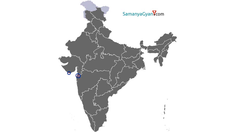
Daman and Diu is a Union Territory of the Indian Republic which is a group of islands located in the Arabian Sea near Mumbai. The capital here is Daman. Daman and Diu is the second smallest union territory in the country. It is located on the east by Gujarat and on the west by the Arabian Sea. Diu is an island connected by two bridges. The neighboring district of Diu is Junagadh in Gujarat. Daman is divided into two parts 'Moti Daman' and 'Nani Daman'. The river dividing these two parts is the Damanganga River.

Before the independence of the country of Daman and Diu, the Portuguese were subjugated. It remained in Portuguese possession long after India's independence. In the year 1961, when the Indian state of Goa was liberated from Portuguese occupation and merged with India. Under the Twelfth Amendment Act 1962 of the Constitution, Goa and Daman and Diu were included in the First Schedule of the Indian Constitution as a territory of the Indian Union. With the 57th amendment of the Constitution, Daman and Diu separated from Goa and became an independent union territory. In 1987, Daman and Diu was declared a Union Territory by the Constitution of India.
Daman is located between 20 ° 22′00 ”to 20 ° 27′25 ″ north latitude and 72 ° 49′42” to 72 ° 54′43 ″ east longitude. The geography of the districts of Daman and Diu makes it a union territory. Daman district is situated on the Indian west coast. In the south it is surrounded by the Kalem River, in the north by the Lord River, in the west by the Arabian Sea, and in the east by Valsad. Valsad in Gujarat is a neighboring district of Daman. Diu is an island connected by two bridges. The neighboring district of Diu is Junagadh in Gujarat. Daman is divided into two parts 'Moti Daman' and 'Nani Daman'. The Damanganga river divides the Daman district into two parts. The major rivers of Daman and Diu are the Gods, Damanganga and Kalem, Kalai and Chhasi rivers.
Daman has a mild and humid climate while Diu has a humid climate.

According to the Constitution of India, the head of the administration of Union Territories is the Governor, who is known as the Administrator and is appointed by the President. Its administration comes under the Ministry of Home Affairs of India. One seat is allotted for Daman and Diu in the Lok Sabha of India.

The current administrator of Daman and Diu is Praful Patel. He was sworn in as Governor (Administrator) of Daman and Diu on August 2016.


The main economic activity here is fishing. There are a total of 550 industrial units in this area. Dabhel, Bhimpore, Kachigam and Kadaiyas are the other industrial areas. The total length of roads in Daman and Diu are 191 and 78 km respectively. There are no railway stations and airports in this union territory.

Major industries here include leather slippers, bamboo baskets and mats, conch items, pearls, straws and handicrafts.


The total irrigated area of Daman and Diu is 393.93 hectares as per the Agricultural Census of the year 2000-01. Important crops are paddy, ragi, millet, jowar, peanuts, pulses, beans, wheat, chiku, sapota, mango, banana, coconut and sugarcane. There is no large forest in this area.
Daman and Diu has a literacy rate of 92.28% as of the year 2011. There are many schools, high schools and government institutions that provide education here. Coast Guard Public School in Nani Daman, Public School in Nani Daman, Institute of Our Lady of Fatima in Moti Daman and Sri Machhi Mahajan High School in Nani Daman are some of the famous schools here.
The major industries here include leather slippers, bamboo baskets and mats, conch items, pearls, handicrafts made of straw, etc.
According to the 2011 census, Daman and Diu has a population of 2,43,247. The population density of the state is 2169 persons per square km. Belongs to The sex ratio of the state is 618 females per 1000 males. Daman and Diu are mostly inhabited by Hindu people.
Women wear saree, kurta salwar, nav-wari (9 inch saree), pano bhaju, kashti, (loincloth) with blanket on shoulder called kunbi, pallo with saree etc. Women and girls also wear skirts, jeans, tops.
The character of the socio-cultural life here is multifaceted because in history it used to be a Portuguese colony. The cultural life here reflects the fusion of European, tribal and Indian elements. Music and dance form an integral part of the socio-cultural life of Daman and Diu. Garba and Dandiya dance is the main dance of this region.
Many languages are spoken in this union territory. Hindi, English, Marathi and Gujarati languages are officially used here. Some elderly people also speak Portuguese. English is used as the official language. Dialects of Konkani, Agri and Worli languages are also spoken here.
The people here are known for seafood. Other main dishes of Daman and Diu include Sea Food, Continental, South Indian, North Indian, Chinese and Mughlai.
In Daman and Diu, people of all religions celebrate their -2 festivals with great pomp. Mainly festivals like Holi, Deepawali, Dussehra, Rakshabandhan, Crisamis, Eid etc. are celebrated here.
Hinduism is the most common religion in Daman and Diu. Muslims are now the second largest religious group in the region, followed by indigenous Christians. The Catholic Christians of Daman and Diu are served by the Metropolitan Roman Catholics of Goa and Daman, who keep their sights on Goa, India's primitive scene.
Daman tourism is a mixture of urban, European and Indian traditions, with Devka Beach being the most famous of all the beaches. Diu is one of the finest destinations in India, with Nida Caves being one of the tourist attractions of Diu. Nagoa Beach is the most famous beach in Diu. Major tourist destinations here include Moti Daman, Nani Daman, Bom Jesus Church, Devka Beach, Jampore Beach, St. Jerome, Jain Temple, ST Cathedral Church, Amusement Park and Gandhi Park, Satya Nagar Gardens, Jampa Gateway, St. Paul's Church, Marwar Memorial, Gomptimata, Chakratirtha Beach, Mirasol Garden, Bom Jesus Church, Jain Temple, Satya Sagar Udyan, Devika Beach, Jampore Beach, Nagoa Beach, Chakratirtha Beach, Gomtimala Beach, Gir National Park, Sasangir Wildlife Sanctuary, Fudum Wildlife Sanctuary etc.
Both Daman and Diu are districts, the area of Diu is 40 sq km. And the population is around 52000, while the area of Daman is 72 sq km. And the population is approximately 2,00,000.

Daman and Diu FAQs:

The capital of Daman and Diu is Daman.

The current Lt. Governor/Administrator of Daman and Diu is Praful Patel (Administrator).

Tarpa Dance, Bhawada Dance, Dhol Dance and Tur and Thali Dance is the main folk dance of Daman and Diu.

The official language of Daman and Diu is English.

The state animal of Daman and Diu is Not yet designated and the state bird is Not yet designated.

Daman and Diu has a state flower Not yet designated and a state tree Not yet designated.

Daman and Diu is spread over an area of 112 sq km with the total of districts.

Daman and Diu was established on 30 May 1987, after which Daman and Diu got the status of Union Territory of India.

  Last update :  Tue 28 Jun 2022
  Post Views :  14822
  Post Category :  Indian Union Territories